Doolin et le Burren!
//.Des photos! Mais quelle denrée rare depuis quelques semaines hen! Donc ma charmante mere est venue me visiter la fin de semaine passée. J'avais déja planifié notre voyage. Nous sommes donc partis samedi vers Doolin, un tout petit village (plus petit que Dingle meme!) qui succombe malheureseument a sa popularité touristique... Néanmoins, ce fut génial! Il n'y avait pas trop de visiteurs (hors-saison) et donc c'était agréable. Nous avons aussi visiter le Burren, nom donné a la région rocheuse-gazonneuse dont la végétation est a la fois méditerranéenne et arctique du comté de Clare! Nous sommes aussi allé voir les falaises de Moher, en bateau! C'était fascinant! Alors je cesse le bavardage pour les photos, commentées bien entendu!
//.Pictures! Finally after a few weeks without them. My mother came to visit me this weekend, I had already planned a trip in the countryside and so we left on saturday for Doolin in county Clare. Even smaller than Dingle, this little town on the west border of Ireland unfortunately is loosing some of its authenticity, victim of its tourism propularity. Nevertheless, there wasn't a lot of people since it is off-season. We had a guided tour of the Burren, region noted for its rocky-grassy landscape carven by long-gone glaciers and flora, quite peculiar as it is a mix of mediterranean and arctic, unique in the world. We also went to observe the fabulous Cliffs of Moher, by boat! Astounding, really! I'll stop the chit-chat for the pictures, duely commented of course!
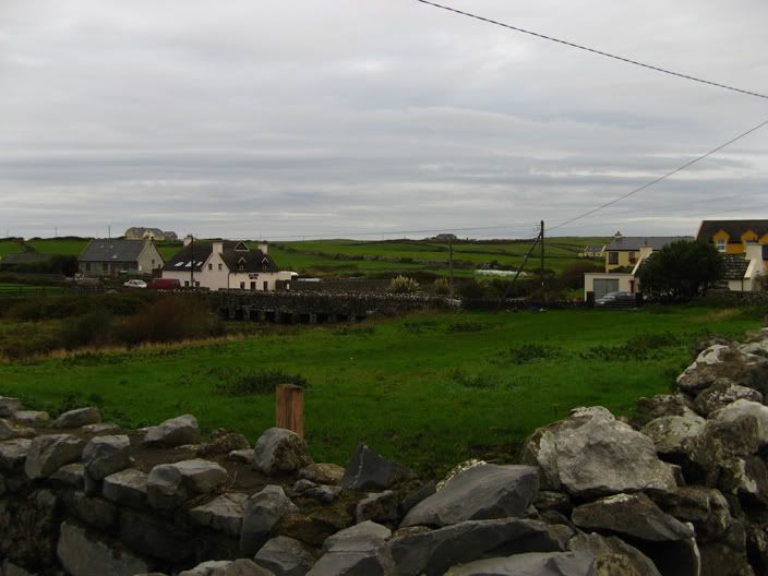
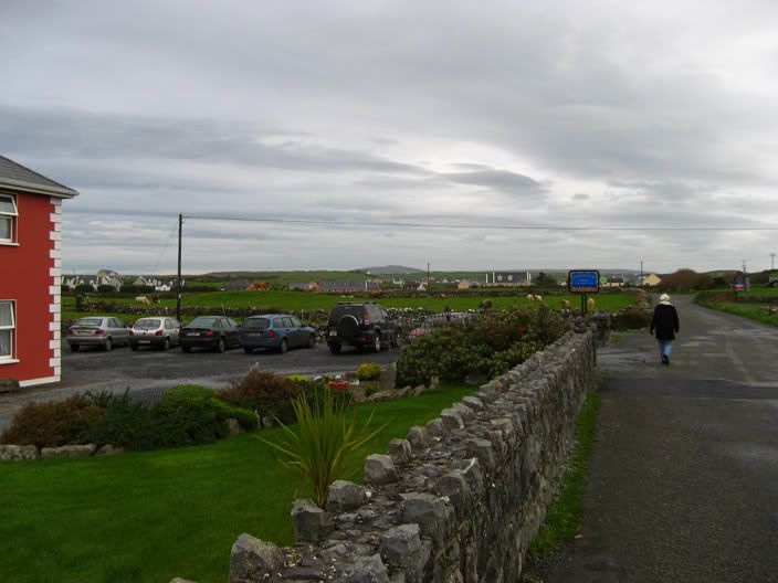
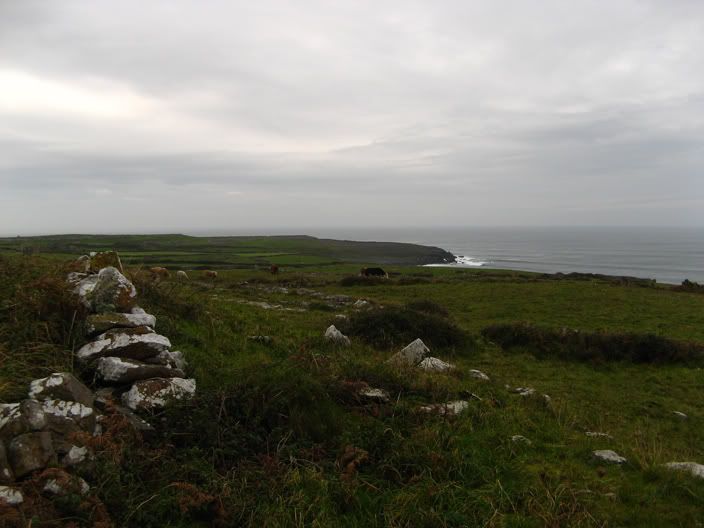
//.Quelques photos de Doolin. Vraiment charmant comme village! Les gens y partagent des terres dans le Burren pour l'élevage de boeufs. On y peche cependant pas vraiment d'apres ce qu'on a pu voir, étrange étant si pres de la cote!
//.A few shots of Doolin. Really charming! The inhabitants share the land in the Burren to take care of the cattle, mainly beef. As far as we know, they didn't seem to fish at all in the area, which is uncommon for a coastal village.

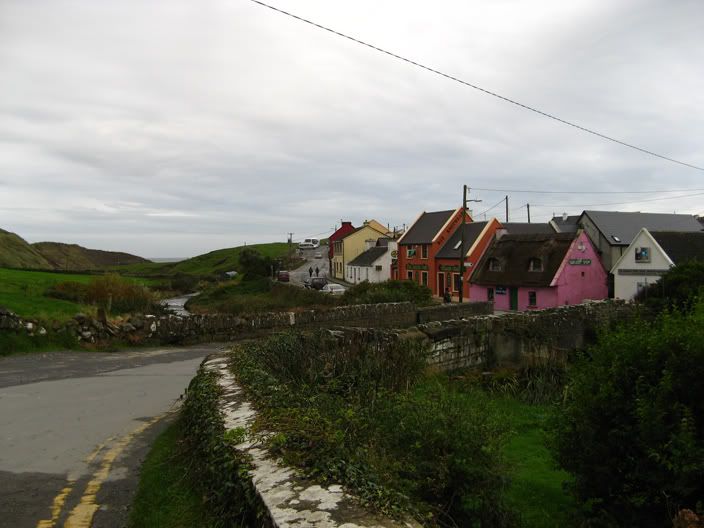
//.Encore Doolin et les falaises de Moher vues de la route principale.
//.Doolin still and the Cliffs of Moher seen from the main road.

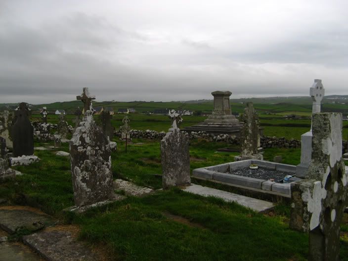
//.Voici un cimetiere de Doolin. Le plus ancien avec les ruines de la chapelle au centre. Un autre cimetiere se trouve un peu plus loin, plus moderne et plus grand a coté de la nouvelle église, elle aussi plus moderne et large.
//.This is one of the cemetery in DOolin, the oldest one I think with the chapel's ruin in the centre. Another more modern and wide cemetary is a bit farther in land, beside a more modern and larger church as well.

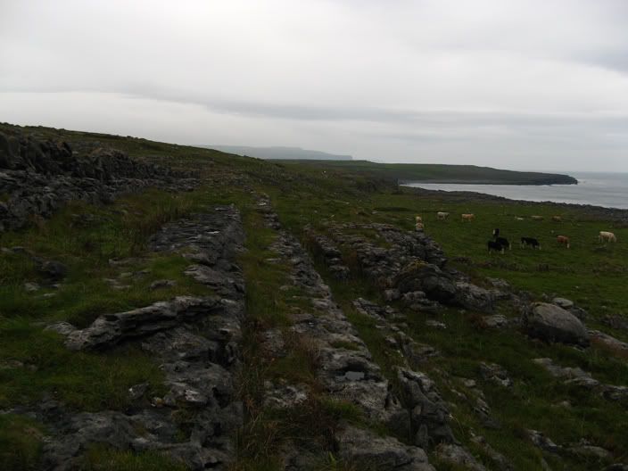

//.Voici quelques photos du paysage du Burren. Les glaciers ont sculpté les pierres et le sol a la fin de l'ere glaciere européenne. Les vents forts et constants ont aussi participés a la création de ce décor en affutant le roc. Il est donc facile d'identifier la direction de ces vents car les pierres ont un coté tranchant et l'autre plat et brut. De grosses tranches de pierres se succedent et de la végétation pousse entre elles et au-dessus. C'est vraiment particulier comme endroit!
//.Here are a few pictures of the Burren. The glaciers sculpted the rocks and the ground at the end of the european ice age. The strong and continuous winds helped forge the landscape by eroding the stones. It is easy to know where the dominant wind comes from as one side of the rocks are sharp and shear and the other, blunt and flat. Large slabs of rock line up one after another with plants growing between and over them. It is a really particular site (and sight!).
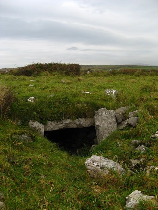
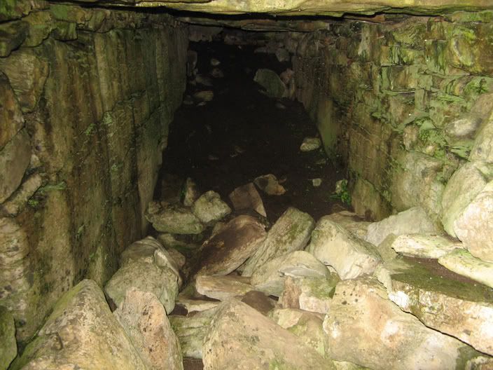
//.Voici l'entrée d'un souterrain qui servait a conserver la nourriture il y a de cela plusieurs centaines d'années. Eparpillé a travers la région, on peut voir des restants de forteresses circulaires et d'habitations de pierre.
//.Here's the entrance of a subterranean food storage. It was used hundreds of years ago when people lived in circular forts and stone houses, of which only remnants and ruins can be found across the Burren.
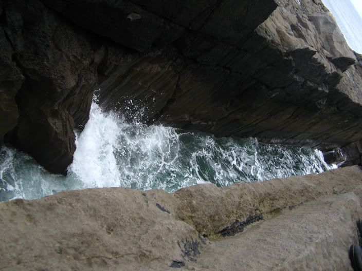

//.Sur la partie la plus pres de la mer, la vegetation disparassait et seul un gros promontoire rocheux s'étendait jusqu'a la rive. Encore une fois, fissuré et crevassé, mais les vagues ont élargi les fentes comme celle-ci, la plus large de la région. C'était impressionnant et étourdissant de voir la mer aller-et-venir, les vagues frappant les parois laissant un gros splash dans le airs.
//.Nearest to the ocean side, the vegetation disappeared and only stone remained. Again, fissured and cracked, but the waves widened them, like this one, the largest of the area. It was quite impressing and dizzying to watch the sea come in and out, the waves crashing against the walls with a huge splash.
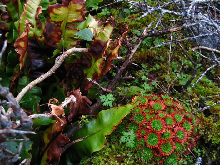
//.Pour finir cette partie, voici un exemple de la flore qui pousse dans le Burren. Des plantes arctiques cotoient d'autres méditerranéennes, unique au monde semble-t-il! Prochain post: Les falaises de Moher!
//.To end this part of our trip, here's an example of the flora growing in the Burren. Arctic plants share this land with mediterranean flowers, unique in the world it seems! Next post: the cliffs of Moher!
//.Pictures! Finally after a few weeks without them. My mother came to visit me this weekend, I had already planned a trip in the countryside and so we left on saturday for Doolin in county Clare. Even smaller than Dingle, this little town on the west border of Ireland unfortunately is loosing some of its authenticity, victim of its tourism propularity. Nevertheless, there wasn't a lot of people since it is off-season. We had a guided tour of the Burren, region noted for its rocky-grassy landscape carven by long-gone glaciers and flora, quite peculiar as it is a mix of mediterranean and arctic, unique in the world. We also went to observe the fabulous Cliffs of Moher, by boat! Astounding, really! I'll stop the chit-chat for the pictures, duely commented of course!
//.Quelques photos de Doolin. Vraiment charmant comme village! Les gens y partagent des terres dans le Burren pour l'élevage de boeufs. On y peche cependant pas vraiment d'apres ce qu'on a pu voir, étrange étant si pres de la cote!
//.A few shots of Doolin. Really charming! The inhabitants share the land in the Burren to take care of the cattle, mainly beef. As far as we know, they didn't seem to fish at all in the area, which is uncommon for a coastal village.
//.Encore Doolin et les falaises de Moher vues de la route principale.
//.Doolin still and the Cliffs of Moher seen from the main road.
//.Voici un cimetiere de Doolin. Le plus ancien avec les ruines de la chapelle au centre. Un autre cimetiere se trouve un peu plus loin, plus moderne et plus grand a coté de la nouvelle église, elle aussi plus moderne et large.
//.This is one of the cemetery in DOolin, the oldest one I think with the chapel's ruin in the centre. Another more modern and wide cemetary is a bit farther in land, beside a more modern and larger church as well.
//.Voici quelques photos du paysage du Burren. Les glaciers ont sculpté les pierres et le sol a la fin de l'ere glaciere européenne. Les vents forts et constants ont aussi participés a la création de ce décor en affutant le roc. Il est donc facile d'identifier la direction de ces vents car les pierres ont un coté tranchant et l'autre plat et brut. De grosses tranches de pierres se succedent et de la végétation pousse entre elles et au-dessus. C'est vraiment particulier comme endroit!
//.Here are a few pictures of the Burren. The glaciers sculpted the rocks and the ground at the end of the european ice age. The strong and continuous winds helped forge the landscape by eroding the stones. It is easy to know where the dominant wind comes from as one side of the rocks are sharp and shear and the other, blunt and flat. Large slabs of rock line up one after another with plants growing between and over them. It is a really particular site (and sight!).
//.Voici l'entrée d'un souterrain qui servait a conserver la nourriture il y a de cela plusieurs centaines d'années. Eparpillé a travers la région, on peut voir des restants de forteresses circulaires et d'habitations de pierre.
//.Here's the entrance of a subterranean food storage. It was used hundreds of years ago when people lived in circular forts and stone houses, of which only remnants and ruins can be found across the Burren.
//.Sur la partie la plus pres de la mer, la vegetation disparassait et seul un gros promontoire rocheux s'étendait jusqu'a la rive. Encore une fois, fissuré et crevassé, mais les vagues ont élargi les fentes comme celle-ci, la plus large de la région. C'était impressionnant et étourdissant de voir la mer aller-et-venir, les vagues frappant les parois laissant un gros splash dans le airs.
//.Nearest to the ocean side, the vegetation disappeared and only stone remained. Again, fissured and cracked, but the waves widened them, like this one, the largest of the area. It was quite impressing and dizzying to watch the sea come in and out, the waves crashing against the walls with a huge splash.
//.Pour finir cette partie, voici un exemple de la flore qui pousse dans le Burren. Des plantes arctiques cotoient d'autres méditerranéennes, unique au monde semble-t-il! Prochain post: Les falaises de Moher!
//.To end this part of our trip, here's an example of the flora growing in the Burren. Arctic plants share this land with mediterranean flowers, unique in the world it seems! Next post: the cliffs of Moher!
posted by db @ 8:13 a.m.
![]()


1 Comments:
At 4/11/06 8:27 a.m., Anonyme said…
Salut David
Cool!! Ça me rappelle des souvenirs et ça m’a fait réaliser comment j'étais chanceux d'avoir eu du soleil à Doolin. Je n’avais pas vu des cavernes comme ça par contre.
Est-ce que ta mère a apprécié l’Irlande (si 1 fin de semaine est assez pour former une opinion hehe)
Ah en passant, je vais au Népal en avri :P
Bonne semaine,
...Mark
Publier un commentaire
<< Home